We took a Ferry to Vancouver Island to visit our last city Victoria. Again my stomach was twisted the whole boat ride, but I finally got to see the Pacific Ocean. It's weird, I though the West Coast would be epic in some way, but it was very similar to the beaches back in Halifax. There was sand and water the crashed against the shore, their scenes were very interchangeable.
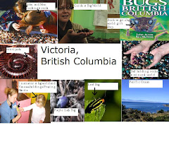
After we arrived in Victoria we visited very Tourist like Attractions. First we visited Mineral World (the facility was as cheesy as the name sounds.) Pretty much there were a bunch of rocks that we could touch and look at. There were also gold panning pools and a pond filled with tropical shells and semi precious stones. Vanessa likes touches the shells, I guess she liked the ruff textures.
We also visited Bug world. I found all the insects and arachnids to be disgusting. However John was fascinated with the creepy crawlies. A guide took around the museum and showed us the different types of bugs. However the highlight of my day: I saw a purple lady bug. (It was a lavender with four black spots, but it was really blurry.)
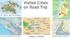
After this trip I`am now proud to be a Canadian. We might not have New York or Hollywood, however we have: Signal Hill, Clifton Hill, Calaway Park, Lake Okanagan, and Bug World. We are all blessed to be born in such a magnificent country, and I had to drive across the country to learn that.
Victoria British Columbia
Latitude: 48 30N
Longitude: 123 25W
Population: 78057
Population Density (people/km2): 3966.3/km2
Landforms: Pacific Ocean
Climate: Victoria does recieve moderate tempertures as it is located on Vancouver Island. Victoira has cold winters because air masses come down from Alaska and Northern Canada to bring cooler air and snow.
EcoZone: Pacific Maritime.
Closest National park: Pacific Rim and Gulf Islands.
Industries: Fisheris, lumber, mining, whale watching.
Tourism: Pacific Ocean, Vancouver Island
Wednesday, July 14, 2010
Tuesday, July 13, 2010
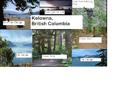
Kelowna, British Columbia
We have now spent two days in Kelowna. The city reminds me of Camp Green Lake from the book Holes, in the sense that it never rains. Kelowna is located in a valley (located between two mountains), therefore it receives little rain due to the Rain Shadow affect.. (The Rain cannot get over the mountain without solidifying so it turns into rain and can not get on the other side of the mountains. Unlike Camp Green Lake, Kelowna has allot of vegetation despite little precipitation.
My parents thought that we have not experienced enough of Canada's natural beauty so they took us on a nature trek. We went to Hike Brants Creek. We entered the park from Downtown Kelowna. I never knew how much of a city girl I actually was. There were annoying bugs, and funny looking plants. I tried to stay in the middle of the dirt road because I was afraid that one plant would give me poison ivy. Thank god the trek went primarily straight, or else I would have got lost in that Jungle like Habitat. I actually found some animals scat, well stepped in it actually. Johns then kept asking what animal it could be from, for fun we made our guesses: mountain lion, grizzly bear, cougar, hyena . (My guess just to freak out Johns because I know he' afraid of Hyena .)
Then we spent a day at Lake Okanagan. The Lake was huge, and really deep. People could swim, but Vanessa could not do anything more then dip her feet. John and Dad tried to fish. To my surprise they actually caught something with there rented fishing rod and tackle box. However being the inexperienced fisher men that they are, they didn not know what to do with it, and had to ask a knowledgeable 12 year old what to do. You could also kayak or water ski, but I spent most of my time swimming in the ocean. I met a girl name Kayla who offered to take me on her families broad in the afternoon. It was a small jet engine. I found out that I get very uncomfortable on boats. I did not want to show it, or be rude, but that boat made my stomach turn upside down.
I am getting excited tomorrow I am going finally to see the great Pacific Ocean.
Kelowna, British Columbia
Latitiude: 49 50 N
Longitude: 119 25W
Population: 106707
Population Density (people/Km2): 504.1/Km2
Landforms: Rocky Mountains
Climate: Kelowna exeperiences very low percipitation because it is located between two mountain ranges. Therefore the Rain shadow effect causes little precipitation. Kelowna is also located near lake Okanagan which cases temperatures to be mild.
EcoZone: Montane Cordillera
Closest National park: Banff National Park
Industries: Agaraculture
Tourism: Lake Okanagan, Wineries
Sunday, July 11, 2010
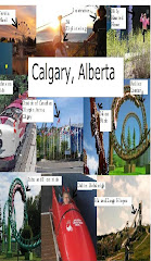
Calgary, Alberta
We have had allot of driving to do as we are on our way to Calgary. My brother and I were about to kill each other. I think we were biologically programmed not to like each other. He sings along to his I-pod which annoys me. So I read my book aloud. Then my parents scold us, ending in a long period of semi silence (We can still hear Vanessa's DVD.)
When we arrived in Calgary we spent a Day in Calaway Park. Calaway is the largest amusement park in the country. It includes classic fair rides like roller coasters and train rides. First we visited the Kiddie section to entertain Vanessa. She enjoyed some of the rides that went slow enough for her. John and I went to and pretended to that we were getting some real adrenaline from those rides. After Vanessa rode the carousel (her favourite ride) a thousand times she took a nap. Then John and I rode the real attractions. We went on roller coasters, which were taller then most houses, and went faster then some cars. I freaked out on the higher drops and yelled hysterically. My mother also took us to play rip off carnival games. John won at the fishing game and chose a medium prize for Vanessa. He made Mom pay a dollar to win a stuffed cow that was probably only worth 75 cents, but he seemed really proud anyway's. Then I watched the indoor shows and left.
The day after we visited the Canadian Olympic Park. The Arena where the 1988 Olympics were held was open as a year round athletic resort. I got to go ziplineing, which I did not find the harness to comfortable. My brother and I tried outdoor wall climbing, which did not give me the adrenaline rush I had hope for. There were also other activities like dirt biking, and falling down a hill in an inflatable ball. The facility also lets you hold the 1988 Olympic torch. While we were holding it John made it very clear that this was not the last time he was going to hold the Olympic torch.
Calgary was another fun stop. I still like Niagara Falls better.
Calgary, Alberta
Latitiude: 51 00N
Longitude: 114 10W
Population: 180,8193
Population Density (people/Km2): 1360.2/Km2
Landforms: Mountains on one side/ Plains on the others.
Climate: Calgary get more rain then it's neighbouring Parrie cities because it has the rocky mountains on one side and parries on the other. This means there to be more precipitation caused by the Rain Shadow effect (clouds can get over the mountains so they liquify to rain.)
EcoZone: Parries
Closest National park: Banff National Park.
Industries: Oil
Tourism: Olympic Arena, Calaway Park, Calgary Stampeed
Friday, July 9, 2010
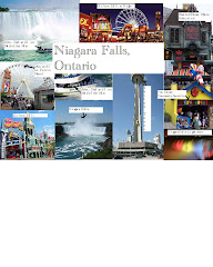
Niagara Falls, Ontario
Finally arrived in Niagara Falls, the best city ever. The city was named after a curved water fall. I did not get the point of watching water fall down on some rocks at first, but it's much more interesting actually to see it. From the viewing areas you can feel the mist trickle against your face. There is also an American water fall, but it's not as interesting. And not even all the water flows down, because a portion of the water supply is diverted to a hydro plant. My brother, father and I decided to ride the Maid of the Mist. We boarded on the docks of the American falls, then a vessel takes you to the basin of the Horseshoe falls. I got so wet even while wearing a souvenir water jacket.
Niagara Falls is also home to Clifton Hill. Clifton Hill has a casino (where my parents lost $100.00) Haunted Houses, Arcades, Museums and a Ferris Wheel. Clifton Hill is my favourite part of the road trip so far. My brother and I went into a haunted house, but I forget the name. First we had to walk through a tunnel with creepy sound effects. I found it to be very fourth gradish. But we got disoriented, and John got scared. We had to climb under something that I could not that I could not really see (it was really dark.) As you are climbing under something grabs at you, which freaked me out. When John climbed under he screamed in terror.
Niagara Falls, Ontario
Latitiude: 43 07N
Longitude: 79 05W
Population: 82181
Population Density (pepople-km2): 392.1/km2
Landforms: Niagara Falls (Curved Waterfall.)
Climate: Niagara Falls recieves the Lake effect because it is located by Niagara Falls and the Niagara river. This causes temperature to be mild.
EcoZone: Mixed Wood Plaines
Closest National park: Point Peelee
Industries: Hydro Power Plants
Tourism: Clifton Hill, Niagara Falls
Wednesday, January 6, 2010
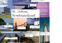
St. Johns, New Foundland
Today we embarked on our, “Journey,” as my father has called it. We woke up and left our Halifax abode at five o'clock in the morning. Then we spent most of the day driving, which was as terrible as I planned. Vanessa had to be entertained with her Wiggles DVD. Everyone had to listen to five middle aged men singing about a big red car. John blasted his I-pod so loud that I could clearly here the lyrics. But the worse part was that he provided his own rendition to his ghetto hip hop songs like, “Candy Shop,” and “Party Like A Rock Star.”
My Father was excited about our stop at St. Johns because we were to see many historic sights. We arrived at Saint Johns late at night, but in the morning we visited Signal Hill. My father's a history major and knew endless facts about some old building. Apparently it was where the first wireless signal across the Atlantic was received. The structure dated back to 1704. For an old building it was very appealing to the eye. We also visited Cape Spear National Historic sight, It was a light house at the most eastern tip of Canada. Dad said it was the oldest surviving lighthouse in Canada. He enjoyed the sight seeing but I was not to interested.
I also swam in the Ocean, and helped Vanessa Jump over waves. But I've swum in the Atlantic thousands of times. I kept on wondering how the Beaches were in British Columbia. I had this vision that the water would be just a bit clearer, and the sand just a shade higher. But I guess I will find out soon.
St. Johns, Newfoundland.
Laitiude: 47 20N
Longitude: 66 8W
Population: 100, 646
Population Density (people/Km2): 225.6/km2
Landforms: Atlantic Ocean
Climate: St. Johns is located on the costline of the Atlantic Ocean. Because of the Lake effect, the temperatures stay moderate. The current from the Atlantic Ocean brings cold water from the Arctic in the winters resluting in cold winters. The city is also located on high hills whichs will cause the temperature to be colder. (temperture decreases 1 degree celcuis for every 100 miles above sea level.
EcoZone: Boreal Sheild.
Closest National park: Terra Nova
Industries: Fisheries
Tourism: Cape Spear Lighthouse, Signal Hill.
Subscribe to:
Posts (Atom)